Rain is forecast to move in across the Bay as we move into the second half of the week.
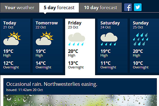
According to the MetService's five day forecast, it will be fine today and tomorrow before showers creep in on Friday and hang around until at least Sunday.
It's looking like a wet weekend in is store. Image: MetService.
The daily highs are expected to sit around the 20 degree mark, with overnight lows of varying from 10-15 degrees as the week progresses.
'A front is expected to cross the South Island on Wednesday and Thursday, with heavy rain in the west,” says the weather organisation.
'The heaviest falls are expected about Fiordland and the ranges of Westland, where 150 to 250mm could accumulate over a 24 hour period.
'Spillover rain is also forecast for the headwaters of the Canterbury and Otago lakes and rivers, and 80 to 120mm could accumulate within 10 to 15km of the divide in 15 to 18 hours.”
The front is expected to move up the country, bringing the rain with it.
In addition to the rain, northwest gales are expected to become severe in eastern areas from Southland to Marlborough ahead of the front, with gusts of 130 km/h in exposed places.
Northwest gales across Wellington and Wairarapa could also rise to severe gales. However, about the Canterbury High Country and foothills, damaging gusts of 140 km/h are possible. Winds of this strength have the potential to damage trees, powerlines and unsecured structures, as well as making driving hazardous, especially for high-sided vehicles and motorcycles.

0 comments
Leave a Comment
You must be logged in to make a comment.