Papamoa's first dedicated tsunami escape bridges are expected to be available for use by the end of the financial year in June.
Tenders for the construction of the first three bridges in eastern Papamoa are expected to be called for later this month or early March with construction expected to start in April.
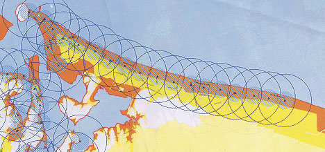
This map shows the inundation zone of a tsunami along the Mount Maunganui and Papamoa coastline with rings showing the audible zone of the proposed siren alert system.
'I suspect they will be starting closer to Easter,” says the Tauranga City Council's transport operations manager, Martin Parkes.
'We have some additional funding in the next financial year and we will be looking to do at least another three.”
The bridges will provide pedestrian access across the drain that lies parallel to Papamoa's shoreline residential development and open country.
'It's really to get people across the drain there, to get them away from the coastal area as quickly as possible,” says Martin.
'We are looking at three metres wide to try and maximise the number of pedestrians we are able to evacuate.
'We don't want them too wide because we don't want vehicles driving across them.
'They won't be strong enough to take vehicles – three metres is ideal for people on foot and on bikes.”
There will be pedestrian links to the escape bridges from the Papamoa side, but for now the bridges will provide access onto the open country between Papamoa east, and the Tauranga Eastern Link highway construction site.
'All that area is going to be developed in time, but it's really giving people the opportunity to get away from that coastal area as quick as possible,” says Martin.
The council's tsunami awareness was focused by the Japan tsunami of March 11, leading to the granting of funding for the bridges and to dusting off plans for a system of tsunami warning sirens.
Proposals on the sirens project have been called for with a report to be delivered at the council meeting on February 20.
There are about 20 road and foot bridges across the drain between Arataki and eastern Papamoa, says Martin.
'There are quite a few opportunities for people to get away quickly.
'We will be doing some signage once we sort out our evacuation plan, but people should have their own plans anyway, and that's the key message.
'Do a bit of homework to know where these access points are.”

12 comments
Posted on 13-02-2012 09:47 | By whatsinaname
so please tell me how far are people going to get on foot
Will the bridges take mobility scooters?
Posted on 13-02-2012 10:00 | By SML
I note the bridges are being built to take "people on foot and on bikes" - but what about the many Papamoa resident whose only mode of mobility is a mobility scooter? Currently we are denied quick access between streets through many of the "beach access" pathways, due to barriers of pipe - will this be the case with these bridges, too? PLanners really need to think this one through properly, considering the aging and disabled population of the area - not everyone is able to walk or ride a bike.
warning
Posted on 13-02-2012 10:26 | By Colleen Spiro
This I assume will only work if we get a couple of hours warning.
How far will they get?
Posted on 13-02-2012 12:06 | By Bronzewing
If they are able to navigate all the private property that needs to be crossed, they will probably be stopped at the highway full cars. This is the most ridiculous scheme ever. Bugger if it's raining as areas where the bridges are proposed are in stormwater drains. Oops and what if it is at night? Do we also get lit paths as well? If not some people in Council are going to get smacked by the OSH fairies.
What an exercise in futility
Posted on 13-02-2012 13:22 | By Ken Ring
Any serious tsunami would still have to come from S America, probably Chile. There have been about 4 events in our history that might be called tsunamis. The first was in 1868 and came across from Chile. Another occurred in May 1960, also the afterwash from a massive Chilean earthquake when waves 2m high entered Lyttelton Harbour damaging boats and a hotel. But we have never had a tsunami generated in local waters. Is it not somewhat a lesson to tsunami-alarmists that there have been 30,000 earthquakes in the past 17 months and not one tsunami. Let us go further than that. At the rate of about 15,000 earthquakes on average per year in NZ, which from 1868 to present would be very roughly 144 years x 15000, or roughly 2 million events, divided by 4 for the tsunamis here that we know about, means a 1/500,000 chance, or 0.0002% risk of an earthquake event becoming tsunamic. That is no risk at all. Even if a tsunami was to come from Chile, we would have 12 hours warning and we could use existing roads and footpaths. Ken Ring Longrange forecaster Auckland
False hope
Posted on 13-02-2012 14:00 | By lpm67
False Hope for the sheeples. The recommendation is that people be at least one km inland and away from waterways when a tsunami hits...most wont make it with the proposed warning times, and if its the middle of the night there will even be more confusion...waste of money! Worse still its lining everyone up in the areas most likely to have high inundation....the waterways! I wish I had a solution to offer but I cant see one at all.
oh dear
Posted on 13-02-2012 15:54 | By traceybjammet
well I guess we better build bomb shelters and evacuation centres and the list goes on and on. Realistically we will have to do our best when trying to survive mother nature and when your numbers up your numbers up, paranoia by press is getting out of control
Tsunami
Posted on 13-02-2012 16:44 | By hanscampp
Has the council decided that a tsunami would be a good way to bring the average age of the city down in one fell swoop? How many elderly are going to be able to get to, and make it across these bridges? Why not alert all bus companies to be on standby at the critical hour in the most vulnerable places? It will save construction costs.
It's a Start
Posted on 13-02-2012 17:55 | By Jitter
Come on, at least TCC are at last taking some action. It may not be the be all and end all of escape systems but it is at least a beginning. Ken Ring is correct with his statistics but that doesn't mean that this coast won't be hit by a tsunami tomorrow. I hope it isn't but unfortunately nature is very fickle and unpredictable. Look at Christchurch. The last place a major eartquake was expected. TCC keep up the good work and get those sirens installed. There are two new schools on the Papamoa coastal strip now so priority should be given to sirens and escape routes.
Yes a complete exercise in futility
Posted on 14-02-2012 08:57 | By KAMIKAZE
Too late to bother with this now as should have been in place 5years ago. Simply connect up Sandhurst Drive with SH2 (about to happen anyway)& make a through connection from Palm Beach Boulevard to Bruce Road and be done with it.Should also be a connection slip road from Gloucester Road through Gloucester Park to SH2 as previously planned.KEN RING'S assessment is flawed in that we do not need 15000 earthquakes just the right one and we are in real trouble.We need to take the proper prudent steps and lets have the Pacific RIM TYPE SIRENS IN PLACE immediately .It is not a question of if but when even if it is 100+ years away !!
Gosh.....
Posted on 15-02-2012 09:23 | By Donnaw
When i was little growing up in Papamoa we were taught to basically run for the Papamoa Hills if the Sirens went off, we even went on a school walk to show us the way up the hill......how times have changed aye....but then again, there probally wasnt as much scare mungering back then either....
Dont Blame the Council
Posted on 15-02-2012 12:22 | By Surfwatch
Its about time that people should start taking responsibility for themselves. Natural disasters are not the fault of Government Local or National. Have your own plan of escape, always be vigilant of earthquakes and their potential for damage and tsunami. If the council can make it a little easier, all the better.
Leave a Comment
You must be logged in to make a comment.