The effects of the very wet summer and continued rain are visible in the district's streams and lakes with water volumes reaching extremely high levels.
Rotorua Lakes Council and Toi Moana Bay of Plenty Regional Council are urging lake users to be extra careful, especially around lake edges where structures may be hiding beneath the surface.
Several lakes are extremely full and water levels have completely covered adjacent beaches, roads and reserves.
This has meant that some boat ramps, jetties, picnic furniture and even playgrounds are now under water and could be a hazard to lake users, especially those in boats and other watercraft.
(1).jpg)
Normal lake levels at Matahi Spit, Lake Rotomā. Image: GoogleMaps.
Where possible, the Harbourmaster has fixed buoys to some submerged public jetties to mark their location, however there are a large amount of other public structures or privately owned structures that may not be visible.
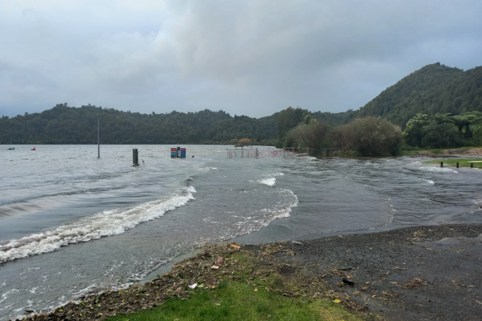
Rotorua Lakes Council has placed temporary fencing around areas where safety and access is compromised such as Matahi Spit and Merge Lodge.
Public barbecues and toilets around the lakes have been affected by the high water and should be used with caution also.
To anyone planning on braving the cooler weather and taking a dip, the advice is, as always, to check the water's depth and make sure there are no hidden rocks or other hazards.
There is also the risk of becoming caught on structures submerged in the water.
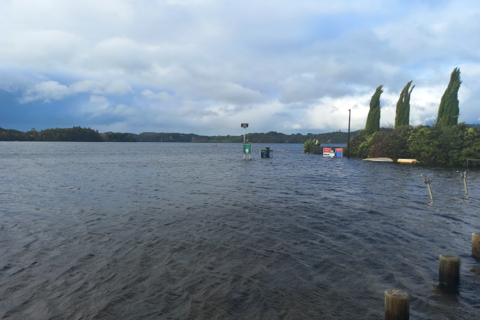
The access road is blocked at Merge Lodge on Lake Rotomā, with public toilets and boat ramp closed. Photo: Supplied.
The lake levels being seen now are close to those seen in the 1970's says Helen Creagh, Rotorua Catchments Manager, Toi Moana.
'Winter is usually when we see a natural fluctuation of the levels, however a wet summer and multiple cyclones have made them higher than usual. Climate change will likely make these extreme weather events more common.
'Heavy rainfall also brings other water quality issues when nutrients are flushed off the land and into the lakes. We track lake levels year-round to understand and plan our activities around these issues.
"Our aim is to monitor and understand flood risks, manage environmental protection and address community concerns.”
Lake and stream edges will also be prone to erosion where the water is higher than normal.
Conditions can change rapidly so it's important to take extra care walking near waterways and report any issues to Rotorua Lakes Council on 07 348 4199.
It's likely that it may be some time before water levels decrease and public spaces and amenities are safe and useable again.
Together, Rotorua Lakes Council and Bay of Plenty Regional Council will continue to monitor lake levels and their surrounding public spaces over the coming months.
Public access to monitoring data is available at Data - Bay of Plenty Regional Council WebPortal (boprc.govt.nz)
The areas with known issues are:
- Access road blocked at Matahi Spit on Lake Rotomā where water has completely covered the road. Also no electricity to public BBQs at this reserve.
- Access road blocked at Merge Lodge on Lake Rotomā, public toilets and boat ramp closed.
- Access to the jetty blocked at Reeme Street on Lake Rotorua, caution as further erosion may also have affected the boat ramp.
- Access to parts of lower tracks at Lake Tikitapu and of the adjacent reserve is variable.
- Areas of lake edge erosion at Hamurana Reserve on Lake Rotorua.
- Stream edge erosion on the Utuhina walkway in Ray Boord Park.
- Erosion and damage to walkway and eastern boardwalk at Motutara Point, Lake Rotorua.
- Erosion and damage to the walkway along the Puarenga stream.

0 comments
Leave a Comment
You must be logged in to make a comment.