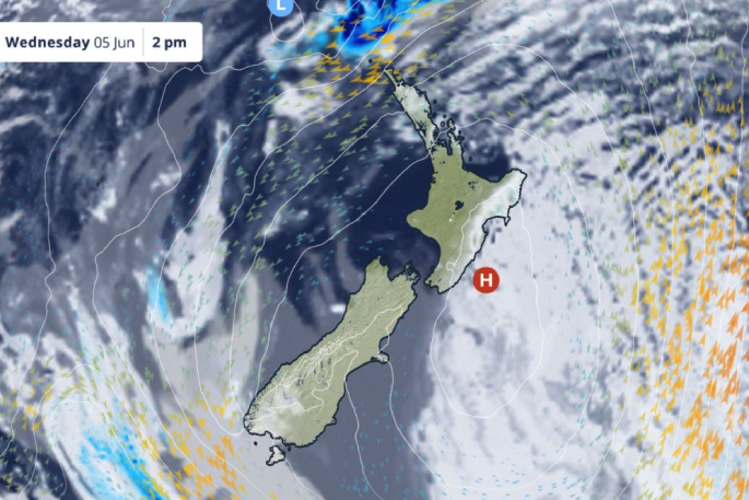
As meteorological winter begins, MetService is forecasting a settled start for Aotearoa New Zealand, thanks to a ridge of high pressure establishing itself over the country this week.
Most regions were greeted by clear skies this (Tuesday) morning, with the exception of the eastern North Island, which saw cloudier conditions.
“High pressure makes it hard for weather systems to develop in an area.
“However, the resulting onshore flow along the eastern North Island is feeding moisture over the land, which could trigger the odd shower today and tomorrow (Wednesday),” MetService meteorologist Mmathapelo Makgabutlane says.
The other exception was Northland, which was under a swathe of cloud streaming from a weather system to the north of the country. Despite this, the system is not expected to impact Aotearoa New Zealand.
“This high pressure over the country is having a blocking effect, so the weather system to the north is just not able to get past that roadblock to reach us.
“So, while Northlanders can still expect cloud and a few showers for the next couple of days, things remain settled for the rest of the upper North Island,” Mmathapelo says.
High-pressure systems are typically associated with calm weather, but they can sometimes lead to ripe conditions for low cloud.
“We’ll be keeping our eye on places that could see some low cloud tonight and tomorrow morning, such as the lower North Island and eastern South Island,” Mmathapelo says.
The South Island is also set for settled weather this week, which will be briefly punctuated on Thursday by a weak weather system bringing short-lived rain to the west and far south.
Looking ahead, the next weather system is expected to arrive during the latter half of the weekend, bringing wet and windy conditions to many parts of the country.
“It is still a while away and things could change, so be sure to keep an eye on the latest forecasts at MetService.com,” says Mmathapelo.


0 comments
Leave a Comment
You must be logged in to make a comment.