July might have big storms in the Southern Ocean but it may be high pressure near Tasmania and New Zealand that dominate the first half of the month, says a Weather Watch spokesperson.
"Despite July in NZ kicking off with an active cold front and low pressure, the high pressure zone near Aussie will influence NZ’s weather for the first half of this month. Welcome to true winter.
"Initially, this set-up brings temperatures down across New Zealand to average or below average (except the West Coast). It's possible things will warm up as the high moves past NZ and alters the airflow mid to late month.
"At this time of year nailing trends more than a few weeks out around the Southern Ocean can be extremely hard due to so much chaos in the atmosphere - so there is more uncertainty about the weather pattern for the last week of July with so much high pressure in the NZ area.
"It's possible high pressure may linger in the NZ area through all of July. But the wildcard here is that the tropics also look more active... so worth monitoring in case a low forms. At the time of publishing this edition of ClimateWatch the high pressure belt(s) looked stronger.
"Despite rain and snow kicking off July 1st to 3rd, the south-west lean (overall) to NZ's airflow (even if you locally have other wind directions) means that most wet weather looks to be in the west to south-west of NZ.
"This is good news for the eastern North Island which wants a breather following the flooding in late June - but not great news for Canterbury which could really do with more rain - along with other parts of central NZ (lower NI, upper SI).
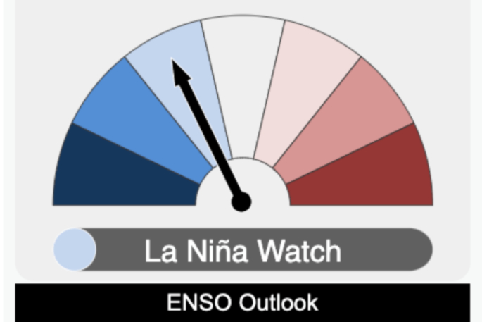
"We are still in a NEUTRAL season (ie no La Niña or El Niño) - and that is certainly showing up in the weather we’ve experienced these past two months.
"Mainstream news outlets are quite obsessed with La Niña and have been for months, but as we've said for just as long this may not impact our weather for many more months to come, or even at all in 2024 (although the data suggests very late spring or summer has some LN chances).
"We are in a neutral set-up right now and we see no signs of that changing. Neutral weather patterns equal more chaos.
"So perhaps put aside the La Niña headlines for now, they can be a bit exhausting. Like a vehicle, we can't just go from first gear to reverse in one movement - we need to go to neutral and then transition.
"We are in neutral now and based on most global modelling there is great uncertainty about La Niña and how it may even impact our weather forecasts later in the year. With that in mind, we may be stuck in neutral for months.
"Put briefly: JULY looks to lean drier than usual, with temperatures starting off average to below average, and likely leaning more average to above average mid to late month."

0 comments
Leave a Comment
You must be logged in to make a comment.