Future coastal developments in the Bay of Plenty will have to include high rise buildings to gain planning approval, a recently released SmartGrowth study reports.
The recommendation is a response to a report commissioned by the Bay of Plenty Regional Council to look at the potential death toll incurred by possible tsunamis.
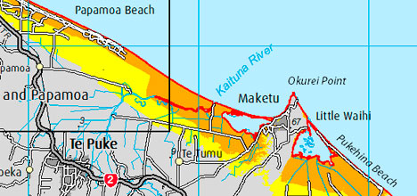
Future urban development at Te Tumu will have to be designed with tsunamis in mind, by keeping areas of high ground and using high rise buildings to provide ‘vertical evacuation facilities' in order to obtain resource consent.
Further work is required to demonstrate that development could be formally approved, the report says.
What's happening is a result of the Boxing Day tsunami in 2004, the Japan Earthquake in 2011. They demonstrated to planners the reality of tsunami risk, and it is now being taken seriously by planners.
'These events have resulted in a changed planning landscape for future settlement,” says SmartGrowth chair Bill Wasley.
'It is our duty of care to respond to the change and ensure we have the best available science as we review and update settlement patterns for these future urban growth areas.
'The tsunami hazard is not new – for generations people have lived and will continue to seek coastal lifestyles in the Bay of Plenty knowing we reside in a tsunami risk area.
'However, the real significance of this research is that it focuses specifically on the scale of tsunami and its implications on strategic land use – particularly for planned, yet undeveloped areas for future development.”
Recent Environment Court case law supports addressing natural hazards through land use planning on the basis of the risk they pose. It's an approach that allows for low likelihood hazards such as tsunami to be addressed depending on their consequences.
As part of a review of settlement patterns, Bay of Plenty Regional Council commissioned the Institute of Geological and Nuclear Sciences to examine the tsunami risk to the coastal growth areas of Papamoa, Wairakei and Te Tumu.
GNS completed two reports; the first was an assessment of the size and scale of the tsunami hazard to the study area and the second – specific to Te Tumu – considered how the risk could be mitigated to an acceptable level.
The risk categories; acceptable, tolerable and intolerable, are a technical assessment of risk providing information for local authorities and communities to use when deciding on what level of risk they are prepared to accept, and what mitigation measures are needed.
They are calculated on best guesses of the numbers likely to die in any particular tsunami, based on the likelihood of one tsunami per year with no forewarning and no evacuation.
Acceptable means the tsunami would result in no more than one death per million people. No action is needed.
Tolerable means the tsunami could kill more than one person per million, but less than one in 10,000. Tolerable risk should be reduced where practical.
Intolerable risk means the tsunami will kill one or more per 10,000 people. Intolerable risk must be avoided in areas of new development.
Twelve tsunami scenarios were modelled:
In Papamoa, seven scenarios are acceptable risk, one is tolerable risk, and four are intolerable risk.
In Wairakei, nine scenarios are acceptable risk, and three are intolerable risk.
In Te Tumu, five scenarios are acceptable risk, three are tolerable risk, and four are intolerable risk.
The ‘intolerable risk' category results from imagined tsunamis originating from the Kermadec Trench. The Kermadec Trench is about 1000km long running from off the tip of East Cape up to near Samoa.
A ‘land threat' tsunami, one big enough to cross over the foredune, from the Kermadec Trench will have less than one hour's travel time to the nearest coastline.
The most common causes are very large earthquakes. In the Bay of Plenty, a land threat tsunami could result from an earthquake greater than 8.5 on the Richter scale.
The current best information indicates that a significant tsunami can be expected to take place every 300 to 1000 years. In general, the bigger a tsunami the less likely it is to occur.
The designated intolerable risk areas means that SmartGrowth and the territorial councils are now obliged to do more work assessing where development will be appropriate, and what mitigation measures will be needed to reach acceptable risk.
Further work is recommended to assess the specific risk of other developed and undeveloped urban growth areas, such as North-west Bethlehem, Katikati Stages 1 & 2, ?mokoroa Stages 1 & 2, and Waih? Beach Stages 1 & 2.
The modelling is based on current sea level and does not account for any sea level rises.
In the Tauranga City area there is estimated to be 51,000 people in areas predicted to be affected by tsunami, with the remainder of the population likely to be indirectly affected by a ‘worst case' event. The number will vary depending on time of year, day in the week and time of day.

4 comments
What happens to the existing residents?.
Posted on 22-03-2013 14:07 | By pomarie
You don't need to be a rocket scientist to work out the impact on populating coastal areas especially lowlands. I suspect council see nothing but greed when issuing resource consents to developers and in turn putting the lives of people in danger of extinction. So what is a fair resolution to this crisis?. Well I think all counsellors should be looking at the immediate problem, and in my opinion, it is the residence that already live there. Move the whole lot of them to higher ground.I don't care where the money comes from. Just do it.
Buy now
Posted on 22-03-2013 16:54 | By pomfart
Cracking idea this. And when the sea level rises by a few metres in the next 50 years due to global warming, the bottom floor will become the pool area for the upstairs residents. Why do modelling based on current sea levels when all the evidence says it's going to rise significantly? I'll tell you why - so some greedy developers and Council can sell the high rise dream to gullible fools. What a waste of money this report is.
open
Posted on 22-03-2013 23:00 | By Capt_Kaveman
join and make more access roads these ant farms accessways are a joke just look around dickson road and simpson areas one way in and out = dumb let alone the no exit to pacific view or evens from the hyway
fools
Posted on 23-03-2013 12:57 | By flipper
Don't you just love the people who build down a gravel road and complain that the council is doing nothing about the dust or sealing their road; or next to Baypark and complain about the noise; or GOD forbid build on sand and then make it someone else's problem for their stupidity! How can you call councils gready for providing what they are asking for? It is you who wants to live next to the sea and if they hadn't given you that abilitly THEY would STILL be the FALL GUY! If you can't take the risks then piss off and live somewhere else. I have been here my whole life and never once lived next to the sea or experienced a tsunami that you all want them spending my precious hard earned cash on to fix your perceived problems. Take a concrete pill and harden up.
Leave a Comment
You must be logged in to make a comment.