Emergency services and Civil Defence are preparing for the worst as a tropical cyclone sweeps close to New Zealand this evening.
Tropical Cyclone Tam, named last night by the Fijian Meteorology Service, is expected to be downgraded again to a storm as it tracks west of Cape Reinga and down through the Tasman Sea.
However, it is still predicted to bring strong winds, heavy rainfall and waves up to 6m across the upper North Island on Wednesday and Thursday.
MetService meteorologist Juliana Bergdolt said Fiji would hand over responsibilities for tracking and measuring Cyclone Tam to New Zealand at 6am today.
She said MetService would be liaising with Northland and Auckland Emergency management this morning after analysing the cyclone to see if any warnings or watches needed to be upgraded.
Bergdolt said MetService is continuing to forecast severe winds and heavy rain for the upper North Island and 4mm of rain had already fallen in Northland overnight.
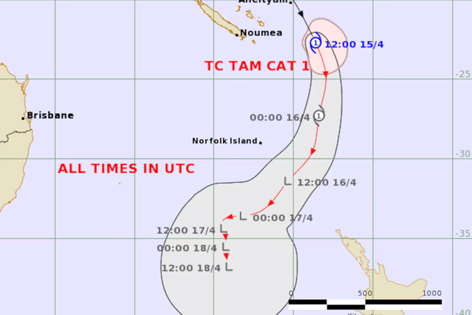
In an update overnight, the Fiji Meteorological Service said the cyclone was moving south at 20 knots or 37km/h. The wind close to the centre was 45 knots, or 83km/h, but is expected to drop to 30 knots, or 56km/h, within 24 hours.
The map showed the cyclone hitting far west of the country, however, this does not mean its impacts could not still be severe.
Heavy rain is expected to lash Northland for more than 41 hours with residents being told to expect 120 to 180mm of rain.
A heavy rain warning came into effect at 3am.
“[The] rain [is] easing for a time Wednesday afternoon and evening.
“Peak rates of 15 to 25 mm/h likely on Thursday with possible thunderstorms.”
A strong wind watch for the region is forecast to begin at 3pm and will last until 8pm tomorrow.
MetService’s forecast is for “severe gale easterlies gusting 120km/h in exposed places, with damaging gusts of 140km/h possible overnight Wednesday and Thursday morning, especially in the north.”
A strong wind watch is set to begin for the Auckland region at 9pm and last until midnight Thursday.
MetService said on its website: “Damage to trees, powerlines, and unsecured structures possible. Driving may be difficult, especially for high-sided vehicles and motorcycles.”
Heavy rain watches have also been issued for Auckland, Great Barrier Island and the Coromandel starting from 3am tomorrow until early Friday morning.
As Niwa (the National Institute of Water and Atmospheric Research) put it in a post on X: “The weather could get pretty gnarly”.
MetService meteorologist Alec Holden agreed with the Fijian Meteorologist Service’s labelling of the storm as a tropical cyclone.
“On our own tropical cyclone activity page, we have it increasing from a tropical depression to a category one cyclone,” he said.
“We have a moderate to a high risk of it upgrading.”
Holden said it wasn’t likely to last as a cyclone when it reached New Zealand.
“It will have a brief flirt with becoming a tropical cyclone, but when it travels lower into the latitudes, that will transition back.
Five and 6-metre swells have also been predicted for Northland, north Auckland, Coromandel and Gisborne.
The Auckland Harbour Bridge could be closed or have speeds lowered at short notice and motorists should be careful on the roads, NZ Transport Agency Waka Kotahi said.
Auckland Transport said public transport could be affected due to a higher risk on the roads.
“We’re advising Aucklanders to be safe and plan ahead. There will be a higher safety risk out on the roads, and some public transport services may also be affected - especially ferries,” a spokesperson said.
Auckland Emergency Management general manager Adam Maggs told Newstalk ZB that residents should prepare their houses for the storm.
“That means moving and securing outdoor furniture and clearing drains and gutters,” he said.
“If our community sees there is a stormwater blockage, call Auckland Council and we will be able to deal with that.”
Maggs also advised Auckland residents to put their rubbish bins out on the day of collection rather than the night before.
He also said people should report downed trees on the Auckland Council website so arborists could quickly remove them.
Maggs suggested Auckland residents should create a plan and check their emergency supplies if power was to go out.

0 comments
Leave a Comment
You must be logged in to make a comment.