The Bay of Plenty Regional Council is seeking public submissions on its plan to divert about 20 per cent of the Kaituna River's flow through the Maketu estuary via Ford's Cut.
The closing date for the submissions is on October 9.
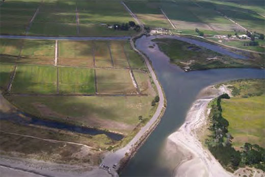
The Kaituna River mouth showing Ford's Cut.
The plan's intention is to return a portion of the river flow back through the estuary to revive the drained wetlands and provide associated recreational opportunities.
The diversion requires multiple resource consents from the BOP Regional Council under its Regional Water and Land Plan, Regional Coastal Environment Plan and Regional Air Plan.
Western Bay of Plenty District Council has also issued a notice of requirement for the designation of land for the construction, operation and maintenance of the re-diversion.
The notice of requirement relates to approximately 76 hectares of land located in the lower reaches of the Kaituna River in the vicinity of Ford Road.
This includes 30 hectares during construction and 46 hectares on a permanent basis for the on-going operation and maintenance of the work.
The lower Kaituna River has been significantly altered during the last century to reduce the flood risk to adjacent lands.
Alterations have created negative ecological and cultural consequences.
Major physical works undertaken since 1900 reduced the flood-risk to surrounding properties, but negative ecological and cultural effects include in-filling of the estuary, loss of kai moana, and a reduction in habitat for native plants and animals.
The Kaituna River and Ongatoro/Maketu Estuary Strategy seeks to redress some of the negative effects by re-diverting water from the Kaituna River back into the estuary.
The council re-diverted tidal flows back into the western end of the Papahikahawai channel by excavating 80m3 of sand from the Maketu Spit in 2012.
The BOP Regional Council resource consents relate to the following activities:
Earthworks and vegetation removal activities due to their volume and proximity to the Coastal Marine Area and the Kaituna River bed.
Placing structures within the Coastal Marine Area and the Kaituna River bed.
The diversion both temporary and permanent, of water from the Kaituna River.
Reclamation within the Coastal Marine Area and the Kaituna River bed.
The temporary take of water and discharge of sediment to the Coastal Marine Area and the Kaituna River during construction; and the modification of the Ongatoro/Maketu Estuary and the Lower Kaituna Wildlife Management Reserve wetlands.
The resource consent application and notice of requirement (including assessments of environmental effects) can be viewed during normal office hours at Bay of Plenty Regional Council, 5 Quay Street, Whakatane; Bay of Plenty Regional Council, 6 Rata Street, Mount Maunganui; or at Western Bay of Plenty District Council, Te Puke Library & Service Centre, 130 Jellicoe Street, Te Puke.
Alternatively, a CD copy is available on request by phoning 0800 884 880.

2 comments
ALL
Posted on 11-09-2014 17:30 | By Capt_Kaveman
of the river needs to go back to its original course with any high flows going out at fords cut re flood protection
Kaituna Cut
Posted on 11-09-2014 20:07 | By bogside
How about an adjustable mechanical weir electronically controlled by tide data? That would maintain proportional flows to both channels even under flood conditions.
Leave a Comment
You must be logged in to make a comment.