The Waikato Regional Council is developing an online tool to help people see the impacts of projected sea level rise scenarios on coastal properties.
Though the tool will allow people to see how different scenarios may affect coastal areas, it will not be able to make predictions about when such sea rise levels may occur.
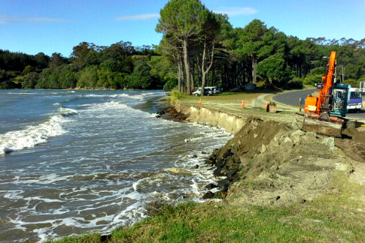
Repair work at Cooks Beach following Cyclone Pam in March of this year. Photo: File
But senior regional hazards advisor Rick Liefting says the tool will let people choose for themselves what the most likely water levels will be over what time frame.
'Basically this is a tool to let people see where the sea may rise to under various scenarios that they self-select,” says Rick. 'People will be able to make their own judgment, based on advice from a range of agencies, on when those scenarios might actually occur.”
The tool and the data it will model is going through a process of being tested, checked and consulted on with key stakeholders before being made available by March of next year.
The modelling work is being done under the council's regional hazards programme and part of the team's brief is to provide good quality public information on risks.
Its development follows comments made recently by the Parliamentary Commissioner for the Environment, who said councils had a role to play in informing and educating the public on the risks.
Projected sea level rise is likely to exacerbate already at risk areas and significantly increase risk in other areas.
But planning now for the future allows the council time to 'manage impacts as best we can,” adds Rick.
The first stage of planning for sea level rise is identifying areas susceptible to projected sea level rise impacts and the new tool will help people with being able to see how it will potentially impact them.
'While there are a range of scenarios and time frames for managing coastal hazard risks, the New Zealand Coastal Policy Statement states we should be looking at effects of sea level rise over at least 100 years for some developments.
'We also need to ensure we are capturing data and monitoring the environment in a way that will provide useful information for landowners and councils to better manage effects of projected sea level rise.”
where residents are already experiencing the impacts of storm surges and sea level rise.

0 comments
Leave a Comment
You must be logged in to make a comment.