
As meteorological winter comes to a close on Sunday, there will be no shortage of weather to herald the changing seasons.
MetService is forecasting weather systems that hold in them the flavours of spring, with strong westerly winds, rain, thunderstorms, and snow in the coming days.
MetService has issued Severe Weather Warnings and Watches for heavy rain and strong wind today and tomorrow (Thursday and Friday).
Settled conditions are set to rapidly deteriorate for the North Island through the remainder of the day as a band of rain with blustery northerly winds move onto the North Island.
Additionally, there is a chance of thunderstorms with heavy rain and small hail for Taranaki this evening.
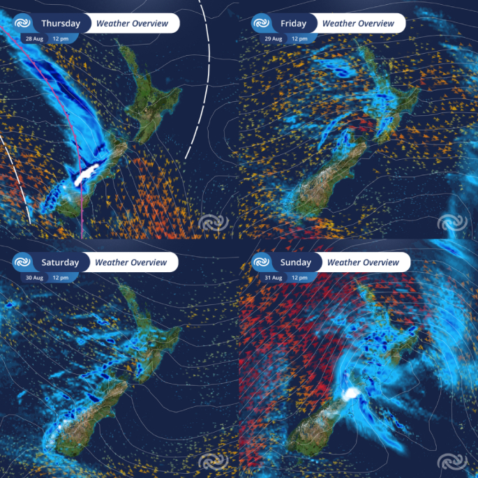 Photo / supplied
In the meantime, strong winds, thunderstorms and rain have already been affecting the South Island.
Observed gusts reached 116 km/hour for Mount Cook Airport, 112 km/hour for Roxburgh Airport and 98 km/hour for Wallacetown this morning.
Furthermore, the chance of thunderstorms with heavy rain and hail continues for the remainder of the day for Nelson, Buller, Grey and Westland.
An orange Heavy Rain Warning is in force for the headwaters of the Canterbury lakes and rivers south of Arthurs Pass until 4 pm today.
Streams and rivers may rise rapidly. Surface flooding, slips, and difficult driving conditions possible.
Strong Wind Watches are in force for the Canterbury High Country, Marlborough and Wellington today as well as Hawke's Bay south of Napier, the Tararua District, and Wairarapa north of Martinborough during Friday
“Damage to trees, powerlines, and unsecured structures is possible. Driving may be difficult, especially for high-sided vehicles and motorcycles. Prepare your property by securing items that can be picked up by strong winds and drive cautiously,” said Metservice meteorologist Alanna Burrows.
On Friday, the strong westerly winds and possible thunderstorms ease by the end of the day.
Temperatures are expected to drop over southern New Zealand; and snow may affect some elevated parts of the South Island, including some of the higher roads there.
Then, as we move into the last weekend of winter, we are expecting to see another boost to winds and swell, combined with fast-moving rainbands.
A strong northwesterly flow builds over the country ahead of another front, which moves onto southern New Zealand late in the day on Saturday and quickly over the country on Sunday, followed by a strong and showery west to southwest flow.
And with a nod to winter, there is a chance that snow may affect some of the higher South Island roads this weekend.
Heavy southwest swell, with heights between 5 to 6.5 metres, is forecast to develop for the western coastlines of the country through Sunday.
“The weekend sees a transition into a breezy springtime setup, and we may find more Strong Wind Watches issued,” said Burrows.
Keep up with the latest information at metservice.com.

0 comments
Leave a Comment
You must be logged in to make a comment.